


Developing in the Expansion Lands
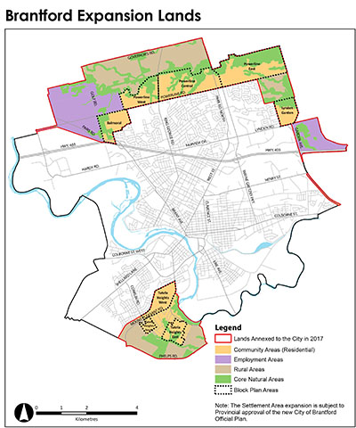
The new City of Brantford Official Plan – Envisioning Our City: 2051 expanded the City’s Settlement Area where urban land uses are designated by approximately 900 hectares. The Settlement Area expansion includes almost 400 hectares for new Employment Areas and nearly 500 hectares for additional residential, institutional and commercial uses and parks (Community Areas).
- The Settlement Area expansion lands are part of the 2,720 hectares annexed to the City of Brantford from the County of Brant in 2017, to enable the City to accommodate growth in new areas, in addition to growth through intensification within existing built-up areas.
Note: 230 ha of Community Area and 125 ha of Employment Area were within the County of Brant Settlement Area prior to the 2017 annexation when they became part of Brantford’s Settlement Area.The Settlement Area expansion lands Area Hectares (ha) Community Area 730
(including 500 ha in the expanded Settlement Area)Employment Area 525
(including 400 ha in the expanded Settlement Area)Rural/Agricultural Area 665 Core Natural Area 800 Total 2,720
To ensure that growth is managed comprehensively, the new Official Plan contains land use designations, policies and maps (schedules) to guide how and where the City will grow. The new Official Plan also requires the preparation of Block Plans for Community Areas in the annexed lands. Schedule 2 of the Official Plan identifies eight areas where Block Plans are to be completed prior to the approval of development applications:
| Powerline West | Balmoral | Tutela Heights West |
| Powerline Central | Lynden Garden | Tutela Heights South |
| Powerline East | Tutela Heights East |
Information about developing in the expansion lands and the Block Plan process is provided below, including links to relevant plans and policies regarding land use and the future servicing of new development. In addition to the new Official Plan, the City has prepared a Master Servicing Plan and Transportation Master Plan to guide infrastructure planning throughout Brantford. The City of Brantford is planning to grow to achieve a population of 165,000 residents and 80,000 jobs by the year 2051 (as per Schedule 3 of the Growth Plan for the Greater Golden Horseshoe).
The new Official Plan, Comprehensive Block Plan Terms of Reference, and Urban Design Manual will guide the Block Plan process and future development in the expansion lands.
- The new Official Plan was adopted by Council on March 23, 2021 and was approved with modifications by the Province, effective August 5, 2021.
- The new Official Plan establishes Block Plan policies (Policy 5.1.f to 5.1.j) and includes a Comprehensive Block Plan Terms of Reference (Appendix B to the new Official Plan) that has been prepared to outline expectations for Block Plan submissions and allow for efficient preparation and review. The Comprehensive Block Plan Terms of Reference sets out a process based on the minimum requirements to complete a Block Plan, summarized in the adjacent chart.
- Block Plans are to be prepared by landowners working together and submitted to the City to the satisfaction of the Director of Planning, prior to development applications. The intent of the process is to co-ordinate the comprehensive development of each Block Plan area and ensure the alignment of subsequent draft plan of subdivision applications, particularly where there are multiple landowners and/or there is potential for development to be approved through more than one draft plan of subdivision. Each Block Plan will illustrate a conceptual master plan layout, determined to be technically feasible in a Block Servicing Strategy, and will form the basis for approvals of draft plans of subdivision and implementing Zoning By-law amendments. Each Block Plan process will be guided by its own Block-specific Terms of Reference, also to be prepared by landowners to the satisfaction of the Director of Planning.
- Proponents are encouraged to meet with Planning Staff to begin the Block Plan process. Please contact planning@brantford.ca with questions regarding Block Plans and to schedule the required pre-consultation meeting.
-
Following the required pre-consultation meeting to begin the Block Plan process, a Block Plan application form is to be submitted along with a draft Block-specific Terms of Reference. The application fee is outlined on the application form and in the City’s development application fee schedule. The Block-specific Terms of Reference will identify the scope of studies required to support the preparation of the Block Plan.
- The new Official Plan also requires that all new development be consistent with the Urban Design Manual, which reflects the City’s commitment to good urban design and provides a consistent baseline for assessing development proposals on both public and private lands. The Urban Design Manual can assist the Block Plan process, as the Manual further articulates a vision and key directions for development in the various land use designations, including the Neighbourhood Centres and Neighbourhood Corridors applied in the expansion lands by Schedule 4 of the new Official Plan.
New infrastructure and upgrades to existing systems are required to service the expansion lands.
- A Draft Infrastructure Staging Report outlines the required water, wastewater, stormwater and transportation infrastructure and community facilities necessary to support development within the expansion. The report summarizes infrastructure projects and prerequisites for each Block Plan area, and also for the new Employment Areas.
- Additional information including macro cost estimates and timeline for the various capital projects are available in the Master Servicing Plan and the Transportation Master Plan.
- The Public Works Commission has also prepared Design and Construction Manuals for linear and vertical municipal infrastructure in Brantford. The manuals are intended to aid in the planning, design and construction, maintenance and operational activities for both new infrastructure and the retrofit of existing infrastructure.
- The Draft Infrastructure Staging Report will be updated after addendum updates to the 2020 Master Servicing Plan and 2020 Transportation Master Plan are completed, to accommodate the extension of growth forecasts from 2041 to 2051.
Environmental Assessment Projects
- The City regularly reviews its 10 year capital plan to ensure growth and non-growth related infrastructure projects are consistent with the recommendations of the Master Servicing Plan and Transportation Master Servicing Plan.
- A number of Environmental Assessments Projects are currently underway in order to consider potential environmental effects before construction of an infrastructure project begins.
North Brantford and Tutela Heights Subwatershed Study
- A subwatershed study involves long-term management and planning for the water resources and natural heritage systems within the study areas.
- North Brantford and Tutela Heights Subwatershed Study is the beginning of a multi-staged approach to fully characterize, evaluate, and implement recommendations for this subwatershed.
Development in the expansion lands is subject to Area Specific Development Charges.
- New Area Specific Development Charges (ASDC) will be applied in the expansion lands, as outlined in By-law 103-2021 and the ASDC Background Study.
- The Fiscal Strategy Report for servicing the expansion lands examines various financing options including developer front-ending agreements to advance the installation of the required infrastructure.

 Subscribe to this Page

