North Brantford and Tutela Heights Subwatershed Study Update - Phase Two
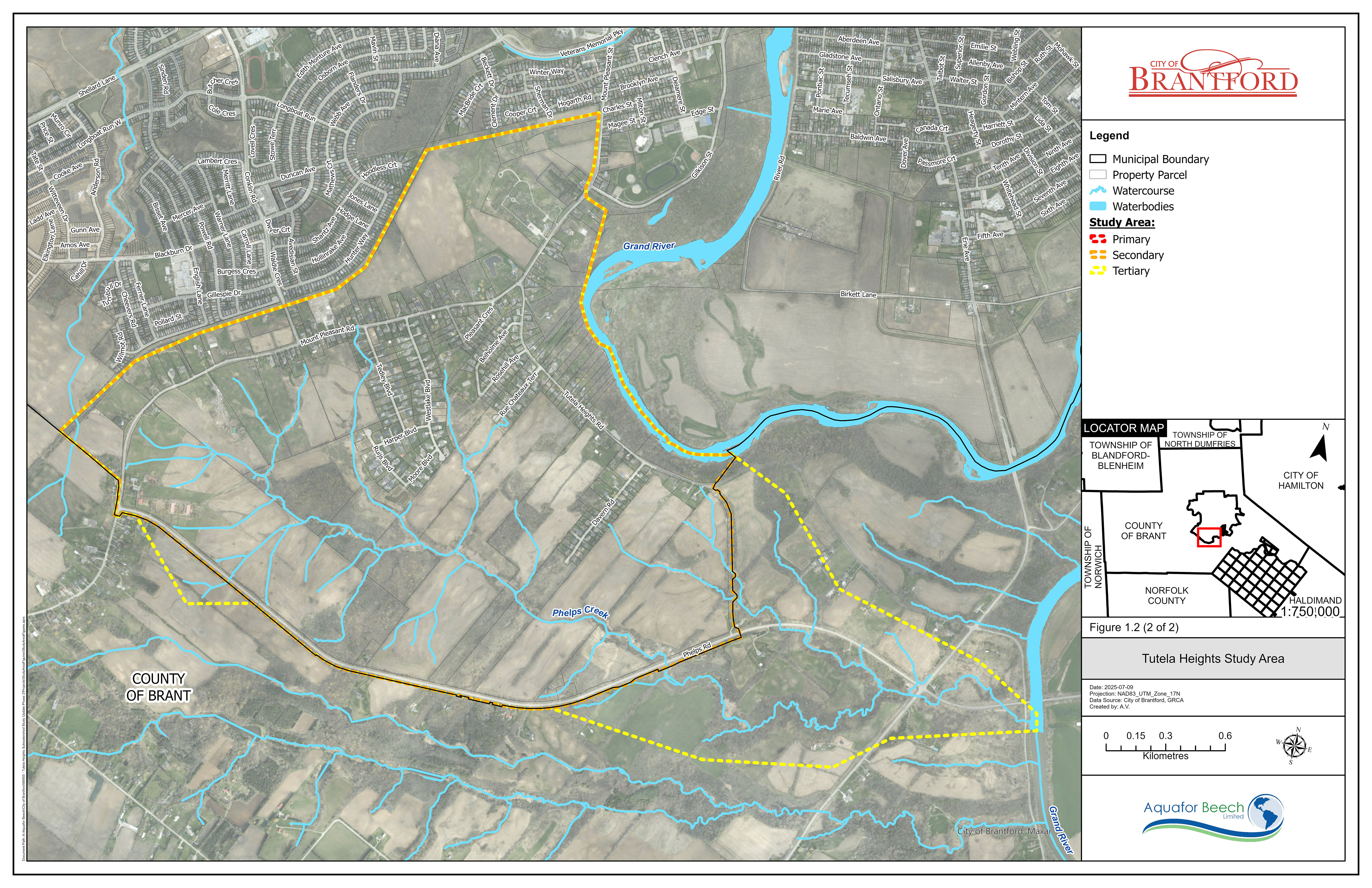
The North Brantford and Tutela Heights Subwatersheds are situated within the 2,720 hectares annexed from the County of Brant through the 2017 Boundary Adjustment. As outlined in the City of Brantford’s Official Plan, Envisioning Our City: 2051, approximately 900 hectares within this area have been designated for future urban development. The North Brantford and Tutela Heights Subwatershed Study plays a critical role in supporting this planned growth while ensuring the protection of the natural environment. Figures 1.1 and 1.2 illustrate the study area boundaries for this subwatershed study.
Figure 1.1
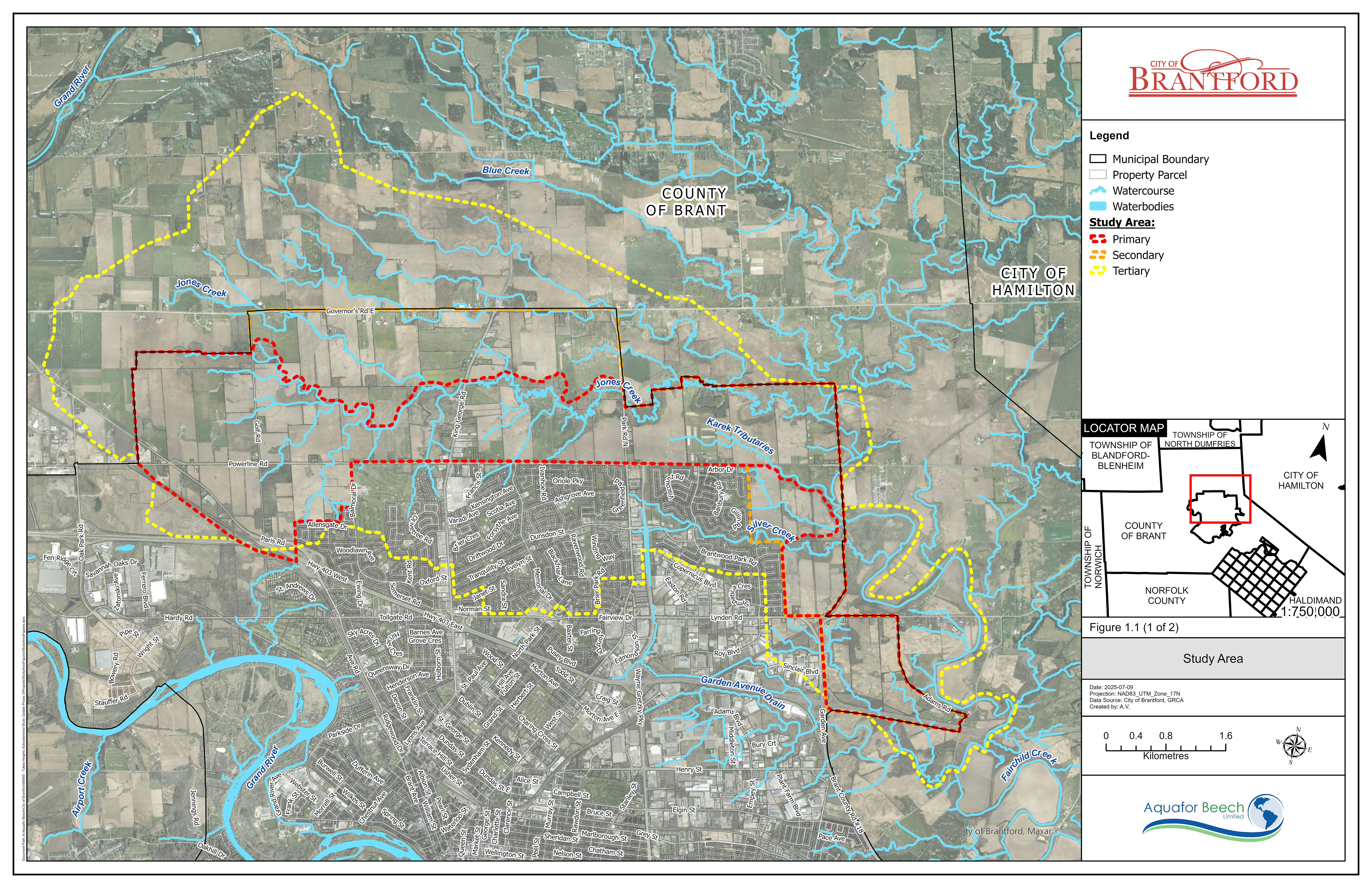
Figure 1.2
What Is the Subwatershed Study?
The Subwatershed Study is a multi-phase initiative that helps the City understand the environmental features of the area and plan for responsible development. It ensures that future growth is balanced with the protection of water resources, natural habitats, and community safety.
The City has completed Phases Two and Three of the study, which builds on earlier work and provides updated technical information and recommendations for managing stormwater, flooding, and ecological features.
Why This Study Matters
As Brantford grows, development planning is essential to:
- Reduce the risk of flooding
- Protect water quality and natural ecosystems
- Support sustainable infrastructure
- Preserve the character and health of local communities
This study provides the foundation for making informed decisions that align with the City’s long-term vision.
Study Background and Timeline
- 2017: The City of Brantford annexed the Boundary Adjustment Lands from the County of Brant to accommodate future growth.
- Phase One (2020): Identified existing environmental conditions and areas for protection or restoration.
- Phases Two and Three (2025): Conducted detailed field investigations, updated hydraulic and hydrologic models, and developed a recommended subwatershed management strategy.
Key Highlights from the Final Study (Phases Two and Three)
1. Environmental and Technical Analysis
- Detailed assessments of sediment transport in Jones Creek and Fairchild Creek
- Identification of groundwater recharge areas and impacts of urbanization
2. Recommended Management Strategy
- A hybrid approach combining traditional stormwater infrastructure with Low Impact Development (LID) techniques
- Measures to improve flood protection, water quality, erosion control, and habitat conservation
3. Natural Heritage Protection
- Mapping of sensitive environmental features and application of protective buffers
- Opportunities for ecological restoration and enhancement of green spaces
4. Implementation and Monitoring
- A long-term monitoring program to track hydrology, sedimentation, and ecological health
- Adaptive management to respond to changing environmental conditions, including climate change
GRCA Regulation Mapping Update
The Grand River Conservation Authority (GRCA) regulates areas prone to natural hazards under Ontario Regulation 41/24. Based on the findings of this study, updates to the regulated floodplain mapping are being proposed. These updates will reflect the most current data and help ensure the safety of people and property.
Once the study is approved by the GRCA’s Board, the GRCA Regulation Mapping will be updated to reflect the updated extent of flood hazards, including the appropriate allowance.
Access the Reports
An electronic version of the draft study is available for download below:
Phase 1 Update Report
The Phase 1 Update Report includes assessments of stream morphology, erosion, surface water and sediment quality, hydrogeology, aquatic and terrestrial ecology, hydrology, stormwater infrastructure, and flooding. It identifies areas for protection, restoration, and enhancement.
North Brantford and Tutela Heights SWS Phase
Final Phases 2 and 3 Subwatershed Report
The Final Phases 2 and 3 Subwatershed Report integrates comprehensive findings and strategies to address urban growth while ensuring the protection of natural and water resources. This document constitutes Phases 2 and 3 of the North Brantford and Tutela Heights Subwatershed Study (SWS), which:
- Updates the hydrologic and hydraulic models, used to update floodplain mapping
- Finalizes constraints mapping
- Identifies protective measures to preserve, enhance, or restore environmental features and functions
- Formulates and evaluates alternative subwatershed management strategies based on environmental, social, and cost considerations, with input from stakeholders
- Selects a recommended subwatershed strategy from among the alternatives
- Provides detailed sediment transport profiles for Jones Creek and Fairchild Creek
- Recommends an approach for stormwater management, natural heritage protection, and climate change adaptation
If you have any comments or questions regarding this study, please contact:
zjawed@brantford.ca
Public Comment Period
The public comment period for the North Brantford and Tutela Heights Subwatershed Study will be open from July 16 to August 6, 2025. We encourage residents, stakeholders, and interested parties to review the study materials and share their questions during this time.
The responses to submitted questions from the comment period are available for review.Subscribe to receive updates from the City
Stay up-to-date on the city’s activities, events, programs and operations by subscribing to our newsroom.


