
A Municipal Class Environmental Assessment (MCEA) is a planning study that helps the City understand municipal infrastructure needs, review different improvement options and identify a preferred solution and design concept. It examines technical, environmental and community considerations before decisions are made or construction moves forward.
Veterans Memorial Parkway Municipal Class Environmental Assessment
Background
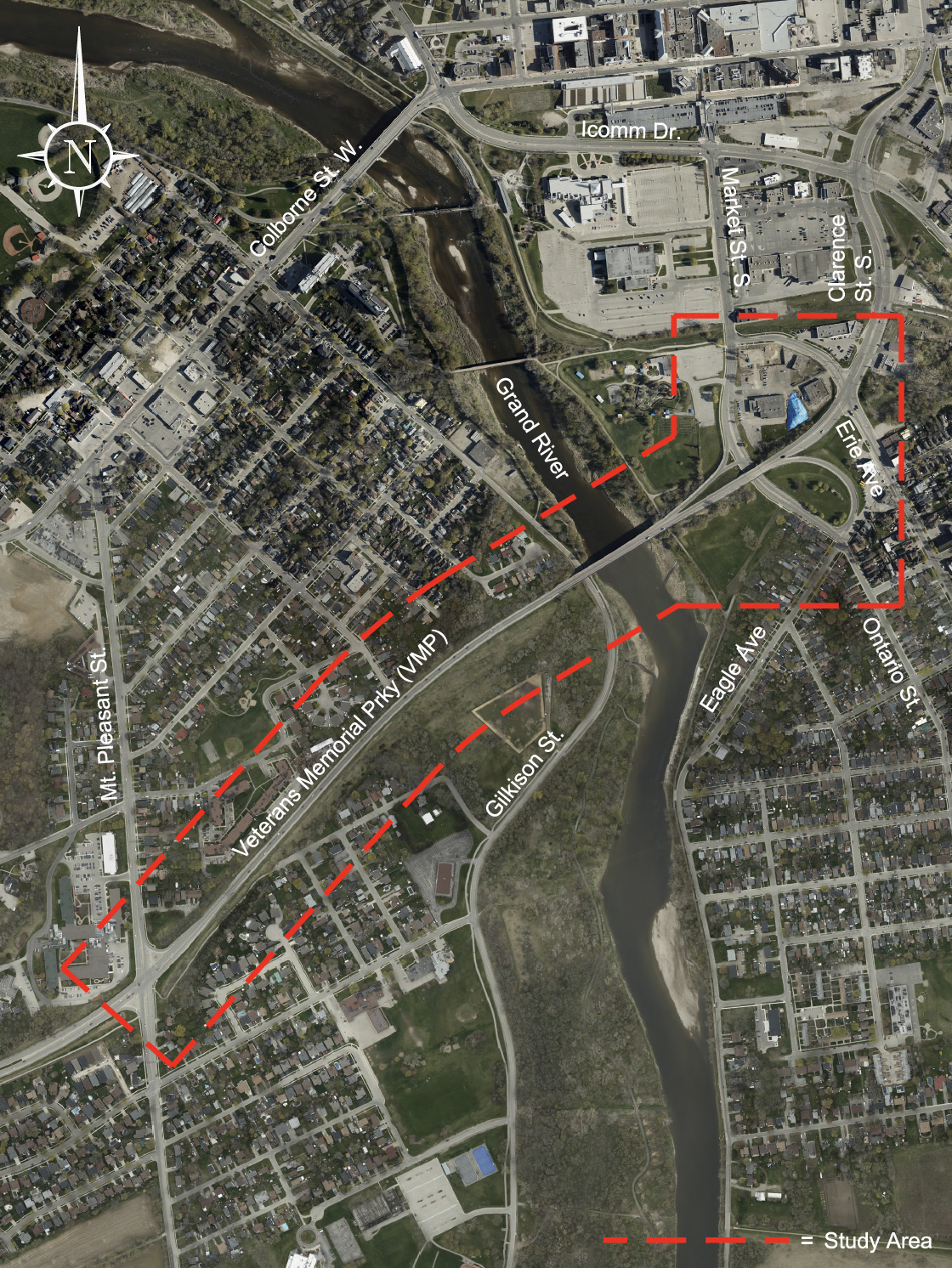
The City of Brantford (the City) is conducting a Municipal Class Environmental Assessment (MCEA) to examine possible improvements to Veterans Memorial Parkway between Mount Pleasant Street and Erie Avenue (the Study). This Study is required to address long-term transportation needs identified in the City’s Transportation Master Plans.
The Study will investigate options such as adding road capacity across the Grand River, widening Veterans Memorial Parkway, and reviewing associated bridge structures, ramps and active transportation facilities. The options will also consider traffic safety, access to nearby properties and future growth in the area.
Why the Study is Being Done
The goal of the Study is to improve traffic operations along Veterans Memorial Parkway while creating opportunities for better walking and cycling connections. The potential use of roundabouts at some existing intersections will also be explored to improve traffic flow and safety.
The Study will review possible effects on the natural environment, cultural features and surrounding community. Feedback will be gathered from Indigenous Nations and Organizations, government agencies, interest groups and the public. All input and decisions will be documented as part of the planning process.
Study Limits
How the Study Works
This project follows a Schedule C Municipal Class Environmental Assessment process (October 2000, as amended in 2007, 2011, 2015, 2023 and 2024), which is approved under the Ontario Environmental Assessment Act.
The project team will identify and evaluate different alternatives and identify a preferred solution. Public input is an important part of the process. Two Public Information Centre (PIC) meetings will be held during the Study. At the end of the Study, an Environmental Study Report will be released for public and agency review.
Notice of Study Commencement and PIC 1
The Notice of Study Commencement and Public Information Centre 1 for this project was first published on September 10, 2026.
PIC 1 - September 2026
An open house style PIC took place on Thursday, September 24, 2026, at Lions Park Arena. PIC display boards are available for review.
Please send any questions you may have to the project team at VMPEA@brantford.ca ahead of the meeting to ensure they are addressed at the PIC.
We Want to Hear From You!
Public involvement is encouraged throughout this project. Residents, businesses, community members, agencies and Indigenous Peoples are invited to share their ideas and feedback.
If you would like more information about the Veterans Memorial Parkway Municipal Class Environmental Assessment or wish to provide comments, please contact a member of the project team.
Guangli Zhang, P. Eng.
Senior Project Manager
City of Brantford
324 Grand River Ave, P.O. Box 818
Brantford, Ontario, N3T 5R7
519-759-4150 Ext. 5705
VMPEA@brantford.ca
Katherine Jim, M.Eng., P.Eng.
Director, Transportation
CIMA+
400–3027 Harvester Road
Burlington, Ontario, L7N 3G7
289-288-0287 ext. 6835
Katherine.Jim@cima.ca
Frequently Asked Questions (FAQs)
What is the Veterans Memorial Parkway Municipal Class Environmental Assessment?
The City’s Transportation Master Plans have identified the need to improve Veterans Memorial Parkway to support future growth and improve traffic conditions. This Study is the next step in planning how those improvements could happen.
The Study covers Veterans Memorial Parkway from Mount Pleasant Street to Erie Avenue, including the Grand River and Market Street crossings, intersections, ramps, bridges and nearby connections that could be affected by future improvements.
What types of improvements are being considered?
The Study is looking at:
- Widening Veterans Memorial Parkway
- Improving traffic flow and safety
- Reviewing the Grand River crossing and other structures
- Adding or improving walking and cycling facilities
- Exploring roundabouts at some existing intersections
- Considering how traffic moves between Veterans Memorial Parkway and surrounding and parallel routes
Will walking and cycling be considered?
Yes. Improving conditions for walking, cycling and other forms of active transportation is an important part of the Study. New or improved sidewalks, cycling facilities and crossings will be reviewed as part of the planning process.
Are roundabouts being considered?
Yes. The Study will review whether roundabouts could work at some currently signalized intersections. This includes looking at traffic operations, safety for all road users and impacts on nearby properties.
Will this study decide exactly what will be built?
No. The Study identifies a preferred option, but it does not finalize detailed designs or trigger construction. If the project moves forward, further design work and approvals would be required.
How are environmental impacts reviewed?
The Study looks at potential environmental effects of the project on the natural environment, cultural features and socio-economic environment. Ways to reduce or avoid impacts are reviewed as part of the process.
Are Indigenous Nations involved in the study?
Yes. Indigenous Nations and Organizations with interests in the Study are being engaged as part of the planning and decision-making process.
At this stage, no decisions have been made about property impacts. Property owners adjacent to the Study area will be notified as the Study progresses. Input from property owners is encouraged and will help inform the decision-making process. Possible effects on nearby properties will be reviewed as the Study develops, and any potential impacts will be clearly identified and communicated.
Public input is an important part of this Study. You will have opportunities to receive information and share feedback through:
- Public Information Centre (PIC) meetings
- Project updates and materials posted on the website
- Contacting the project team directly
All comments are considered as part of the planning process and will remain public record filed with the MCEA, with private information redacted.
What is the Study’s overall schedule?
The MCEA is expected to take approximately 18 months, starting in early 2026 and finishing in summer 2027.
Key milestones include:
- Study initiation: February 2026
- Public Information Centre 1: September 2026
- Public Information Centre 2: Winter 2026–27 (tentative)
- Environmental Study Report (ESR) completed: Spring 2027 (tentative)
- 30-day public review period: Summer 2027 (tentative)
Following the public review period, the Study will be finalized and any required next steps under the Environmental Assessment process will be addressed.
Project timelines may be adjusted if additional review, consultation or technical work is required. Updates will be posted on the project website as the Study progresses.
Subscribe to receive updates from the City
Stay up-to-date on the city’s activities, events, programs and operations by subscribing to our newsroom.


