Wayfinding Signs
On-road Active Transportation wayfinding signs
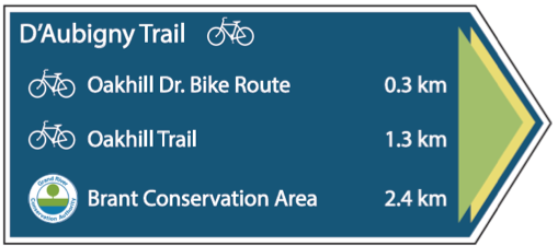
The City of Brantford has designed a new system of wayfinding signs that will be installed throughout the City on the on-road active transportation routes. These signs highlight safe routes for both cyclists and pedestrians and provide information about nearby destinations.
Creating a cohesive cycling network
Wayfinding signs will create a greater level of legibility and understanding of the on-road active transportation network and will assist both residents and visitors in easily navigating their way to major points of destinations in the City. Some of these destinations include City-owned facilities, community centers, parks, schools, Brantford Hospital, Brant Conservation Area, Lynden Park Mall, and other cycling- and pedestrian-friendly routes.
These signs will initially be implemented on the following seven core active transportation corridors in the City:

- North Park Street/Memorial Drive Corridor
- Erie Avenue Corridor
- Veterans Memorial Parkway Trail System
- Shellard Lane Corridor
- Wayne Gretzky Parkway Multi-Use Path
- Garden Avenue Corridor
- Brantwood Park Road Corridor
Be sure to look for the new signs when cycling and walking around the City.


 Subscribe to this Page